Second Attempt for the Mt. Humphrey's Peak...
Was a huge success!
This was hike #25 of my 52 Hike Challenge and I'm so glad that it was. I first attempted Mt. Humphrey's about two months ago and it was a bit of a disaster (more on that experience later). I hadn't done a hike that week and I could feel my moodiness returning to me, so I decided last minute to try this hike again. I did some research to better understand the hike and how best to prepare (last time I relied on the information of the other people in my group, which was a big mistake). My first attempt of the hike gave me some insight as to how the first, and easiest, leg of the hike was going to be, so I knew I just needed a bigger picture.
 In my research I found that there were several "false peaks", meaning that you would look at a peak and think it was THE peak, only to get there and see more peaks beyond that. I would say that there were 4 to 5 of them in the last mile of the hike. That for sure left me feeling a little discouraged at time, but it did make getting to the actual peak that much more satisfying, even just seeing the last peak was enough to almost put me into tears, happy tears.
I also looked up some information on altitude sickness. I was slightly familiar with the symptoms, but not enough to be comfortable since I haven't really done much hiking up mountains, I mostly stick to canyons. To be truthful, I had assumed that I wasn't as susceptible to altitude sickness since I come from a fairly high altitude myself. That being said, I did in fact experience some altitude sickness. I had developed a slight headache about 20 minutes from the peak. Thankfully it dissipated by evening time and after some sleep. Always know your limits. It is OK to not feel well and take a break or even turn around if things don't improve. Altitude sickness can happen to any person, at any time. There is no way to predict if you will succumb to it or not, regardless of your fitness level. Symptoms of altitude sickness are:
 As I mentioned, I really was in a sulky mood prior to this hike. But as soon as I hit the trail and started moving up the mountain, I could feel things improve. My stress ebbed as I started to focus more and more on moving my body further along the trail, one step at a time. As I got into a rhythm, I started to really asses my situation and brainstorm what my next steps in life should be. I do my best thinking and problem solving on the trail. If I were to shrink my own head, I would say that I feel in control while hiking (as much control as one can feel in the wilderness when things can change in an instance) and therefore feel in a place to be able to rationally problem solve. What that being said, who really knows since I'm not a trained professional. Anyway, it felt good to be able to put things in perspective and create tangible steps to getting back on track with things. I really do believe that when you really decide on a path, you put out that energy and set that mentality, and eventually that energy or those efforts come back to you with positive results. I was just in such a better place, emotionally and physically, by the time I got to the bottom of that mountain.


This was hike #25 of my 52 Hike Challenge and I'm so glad that it was. I first attempted Mt. Humphrey's about two months ago and it was a bit of a disaster (more on that experience later). I hadn't done a hike that week and I could feel my moodiness returning to me, so I decided last minute to try this hike again. I did some research to better understand the hike and how best to prepare (last time I relied on the information of the other people in my group, which was a big mistake). My first attempt of the hike gave me some insight as to how the first, and easiest, leg of the hike was going to be, so I knew I just needed a bigger picture.
 |
| View from "the saddle" |

I also looked up some information on altitude sickness. I was slightly familiar with the symptoms, but not enough to be comfortable since I haven't really done much hiking up mountains, I mostly stick to canyons. To be truthful, I had assumed that I wasn't as susceptible to altitude sickness since I come from a fairly high altitude myself. That being said, I did in fact experience some altitude sickness. I had developed a slight headache about 20 minutes from the peak. Thankfully it dissipated by evening time and after some sleep. Always know your limits. It is OK to not feel well and take a break or even turn around if things don't improve. Altitude sickness can happen to any person, at any time. There is no way to predict if you will succumb to it or not, regardless of your fitness level. Symptoms of altitude sickness are:
- Headache
- Loss of appetite
- Fatigue
- Difficulty sleeping
- Dizziness
- Nausea

The Technical Stuff!
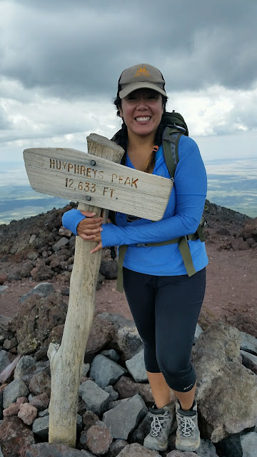
Humphrey's Trail (TR#151) is a 9.6 mile trail leading up to Mount Humphrey's Peak. This is the highest peak in Arizona. The first two or three miles are not too bad. The trail is a steep incline (duh, you are going up a mountain) and there are lot of rocks and tree roots along the way. I personally recommend hiking boots, as I don't like the feel of the terrain beneath my feet. I like my feel safe and secure in some tough boots. However, boots are not required. I saw people in their sneakers doing just fine. There were some spots where the trail was a little confusing, due to people going off trail but otherwise it was all pretty clearly marked. Once you get to the edge of the tree line, the trail really starts to shoot upwards. After that, you reach what people call "the saddle", very aptly named. Here is the auction for the Weatherford trail. I haven't hiked that yet, but it seems fun. It has a lot of cool history. Here is where a lot of people will turn around since this where the tree line officially ends and you begin your ascent to the peak. The saddle is a great place to stop for a snack or just appreciate the scenery since you are already so far up. The trail to the peak is fairly precarious. You are hiking what I would call a edge of mountain. It reminded me a lot of Angels Landing in Zion, but not as extreme. The terrain here is tough and some of the rocks can be slippery. There are poles marked "Trail" to ensure you stay on the right path. The ecosystem there is fragile, so it's important to stay on trail as much as possible. It is along this ridge, that you see all the false peaks. Brace yourself. There were a lot of hikers who offered sage words of advice and encouragement. The traffic is pretty moderate considering the trail. If you an make it all the way to the top you are definitely rewarded with amazing view, showcasing all AZ has to offer. Our wonderful forests and colorful deserts.
Total Mileage: 9.6 miles
Estimated Time: 6-8 hours round trip (it took us 6.5 hours)
Elevation:12,633 Ft
Popularity: Moderate to High
Trail head Location: From the HW17, travel through Flagstaff. You will start seeing signs for Snowbowl, just follow those all the way to the trail head. More specifically, you will travel from the HW17 to HW180 for about 7 miles. From HW180, you will turn onto FR 516, Snowbowl Rd. Drive along that for another 7 miles or so. As you enter into the parking lot of Snowbowl, you will see the sign for the trail head. Park as close as you can!
Conditions: Rocky and uneven
Weather: Check ahead of time. Since you are hiking up a mountain, weather can be unpredictable and storms can swoop in at any time, especially if you go during monsoon seasons. We lucked out and went on the perfect day, blue skies and a little cloud cover. Be sure to just check the Forest Service site.
Notes: I drank all 3 liters of water on this trip. Plus half of my Powerade. Always be sure you have enough water.


Comments
Post a Comment